Terrain Overview
The terrain of a Rust map is a stack of maps over one square of ground. Each map stores one kind of information for every point: the height, the ground texture, the climate, and more. This page explains each map, how big its pixels are, and how prefabs change the terrain.
The terrain's maps
| Map | What it holds | What Rust uses it for | How you change it |
|---|---|---|---|
| Height | The height of the ground. The terrain is 1000 meters tall: from 500 m below sea level to 500 m above it. Sea level is 0. | The shape of the land. | Height tools (Sculpt) |
| Splat | The ground textures: Dirt, Snow, Sand, Rock, Grass, Forest, Stones and Gravel. Each point is a mix of them, and the amounts add up to 100%. | How the ground looks. Rust's spawn rules can also ask for a splat type. | Paint tools, Layer = Splat |
| Biome | The climate: Arid, Temperate, Tundra, Arctic and Jungle. Each point is a mix, like the splat. | Each splat texture has its own color in each biome, so the biome tints the ground. Rust's spawn rules can also ask for a biome. | Paint tools, Layer = Biome |
| Topology | 31 on/off flags for each point, such as Field, Cliff, Beach, Ocean, Road, River, Monument and Mountain. A point can have many flags at once. | Rust's spawn rules and map generator read the flags to decide what goes where. | Paint tools, Layer = Topology |
| Alpha | Holes in the terrain. Where the alpha is low, the ground has a hole. | Openings in the ground. | Paint tools, Layer = Alpha |
| Water | The water level of lakes, rivers and other water prefabs. | Where the water of lakes and rivers is, and how high it is. | You do not paint it. RustEdit makes it from the water prefabs when you export the map. |
The terrain has a hole where the alpha is below 0.5 (half). RustEdit draws the terrain with Rust's own terrain shader, so the scene view shows the holes as the game does.
The spawn groups page shows how Rust's spawn rules read the splat, biome and topology.
A lake prefab adds water to the water map only where the terrain has the Lake or Lakeside topology. Paint that topology under your lakes before you export.
You can also make your own topology maps for server plugins. See Custom topology layers.
Map size and resolution
A map is a square. You set its size in meters when you create it: from 1000 m to 8000 m. Maps larger than 6000 m need the RustEdit 2 server extension on the server to run. See Create, open and save.
Each map has two resolutions, in pixels across the map:
| Setting | Maps it sets | Choices |
|---|---|---|
| Terrain Resolution | Height and water | 513, 1025, 2049, 4097 |
| Texture Resolution | Splat, biome, topology and alpha | 512, 1024, 2048, 4096 |
When you create a map, RustEdit marks a (Recommended) choice for the map size. One pixel covers the map size divided by the resolution. For example, on a 2000 m map with the recommended 1025 and 1024, one pixel is about 2 m wide on both kinds of map.
Brush sizes in the Terrain Tools are in pixels of the map you edit. Sculpt brushes count height pixels, Paint brushes count texture pixels. So the same brush size covers more ground on a bigger map or at a lower resolution.
To change the resolution of a map you already have, use . See Terrain resolution.
How prefabs change the terrain
Many Rust prefabs change the terrain around them. Monuments, cliffs and rocks are the most common. A prefab can carry two kinds of change:
- A placement: pictures of the terrain the prefab wants around it, such as its own heights, splat, biome, topology and holes. Monuments use these.
- Modifiers: simple shapes that set or raise the height, set or remove a splat texture, add or set topology, or cut holes in the alpha map.
RustEdit shows these changes live. Select a prefab and look at the Terrain Modifier panel in the Inspector. It has one switch for each map the prefab can change: Apply Height, Apply Splat, Apply Biome, Apply Topology and Apply Alpha. The panel only shows for prefabs that carry terrain changes, and only the switches the prefab can use. See Terrain Modifier.
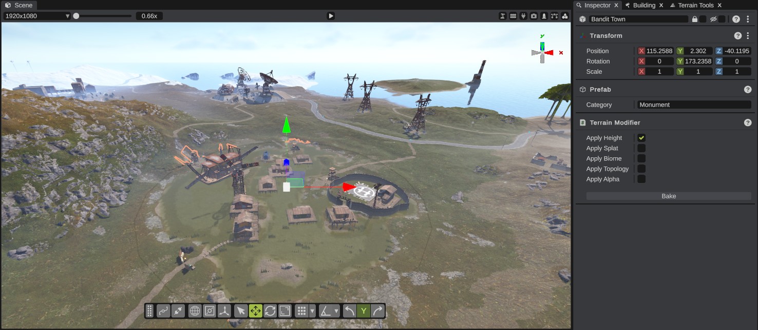
How the changes behave:
- The switches are off when you place a prefab. Turn them on to see the prefab's change on the terrain.
- The change follows the prefab. Move, turn or scale the prefab and its change moves with it. Delete the prefab and its change goes away. Undo brings both back.
- The change is added on top of the map's own terrain. The terrain tools edit the map's own terrain under it. Where a prefab sets the height, sculpting there does not show while Apply Height is on.
- The switches are saved in the scene file.
- When you export the map, RustEdit writes the terrain as you see it, with the prefabs' changes in it.
The Cliff Brush can turn on the modifiers of each cliff it places. The procedural generation bakes the changes of the prefabs it places.
A placed monument that you made yourself has a Monument Terrain panel instead. It works the same way. See Monument Terrain.
Bake
Bake writes a prefab's terrain change into the map's own terrain for good, and turns the prefab's switches off. After that, moving or deleting the prefab leaves the terrain as it is. Bake is on the Terrain Modifier panel of a Rust prefab and on the Monument Terrain panel of a monument you made. It writes only the maps whose switches are on.
Bake is one undo step. Ctrl+Z takes the change back out of the map's own terrain and turns the switches back on, so the terrain looks as it did before. See How Bake works.
The order RustEdit builds the terrain in
The terrain you see is built in this order, each step on top of the one before:
- The map's own terrain: what you sculpt and paint.
- The prefabs' placements.
- The prefabs' modifiers.
- The terrain splines. See Terrain splines.
See the values at a point
While Terrain Tools is on, hold Ctrl and right-click the terrain. RustEdit writes the splat, biome, alpha, topology and height at that point to the Notifications panel.